The idea of entire cities being plunged underwater might sound like the plot of the latest science fiction blockbuster.
But it could become a reality in just 75 years, according to a terrifying new study.
Scientists from Nanyang Technological University (NTU), Singapore, have predicted that global sea levels could rise by a staggering 6.2 feet (1.9 metres) by 2100 if carbon dioxide (CO2) emissions continue to increase.
‘The high-end projection of 1.9 metres underscores the need for decision-makers to plan for critical infrastructure accordingly,’ said Dr Benjamin Grandey, lead author of the study.
‘More importantly, these results emphasise the importance of climate mitigation through reducing greenhouse gas emissions.’
If global sea levels were to rise by 6.2ft (1.9 metres), towns and cities around the world could be plunged underwater – including several in the UK.
So, is your hometown at risk?
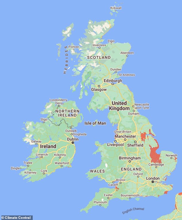
If global sea levels were to rise by 6.2ft (1.9 metres), cities around the world could be plunged underwater – including several in the UK
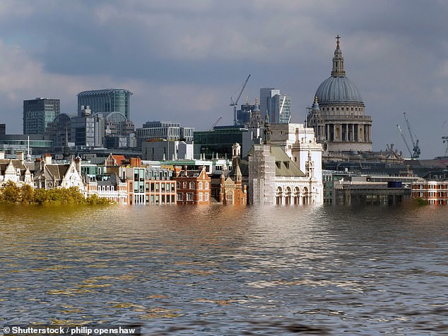
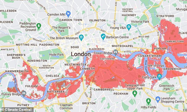
Huge swathes of London would be affected, with several areas on the River Thames gleaming red on the map, including Bermondsey, Greenwich, Battersea, and Chelsea. Pictured: artist’s impression of London underwater
Current sea-level projections rely on a range of methods to model climate processes.
For example, some projections include well-understood phenomena like glacier melting.
But others incorporate more uncertain events, such as abrupt ice shelf collapse.
As a result, these models produce varying projections, making it difficult to estimate reliable sea-level rise.
In its IPCC Sixth Assessment Report, released in 2023, the UN estimated that under high-emission scenarios, global sea levels would rise by between 0.6 and 1.0 metres (1.9 and 3.2 feet).
However, the researchers from NTU took a new ‘fusion’ approach to their estimates by integrating statistical methods with expert judgments.
They claim that this offers a clearer, more reliable picture of future sea-level rise.
‘Our new approach tackles a key issue in sea-level science: different methods of projecting sea-level rise often produce widely varying results,’ Dr Grandey said.
Climate Central’s Coastal Risk Screening Tool shows the areas around the globe that would be worst hit
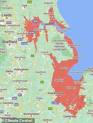
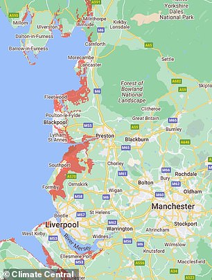
To use the tool, simply set the water level at 6.2ft and the areas that would be plunged underwater will appear in red on the map
‘By combining these different approaches into a single fusion projection, we can estimate the uncertainty associated with future sea-level rise and quantify the very likely range of sea-level rise.’
The fusion model predicts that under a low-emissions scenario, global sea levels are very likely to rise between 0.3 and 1.0 metres (0.9 and 3.2 feet) by 2100.
But under a high-emissions scenario, the fusion model prdicts that global sea levels are very likely to rise between 0.5 and 1.9 metres (1.6 and 6.2 feet).
If the scientists’ most extreme predictions are right and global sea levels do rise by 6.2ft, hundreds of coastal towns and cities could be plunged underwater.
Climate Central’s Coastal Risk Screening Tool shows the areas around the globe that would be worst hit.
To use the tool, simply set the water level at 6.2ft and the areas that would be plunged underwater will appear in red on the map.
Here in the UK, people living on the east coast of England would be worst hit.
Coastal hubs including Hull, Skegness, and Grimsby would be plunged underwater, while places as far inland as Peterborough and Lincoln would also become water logged.
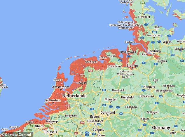
Climate Central predicts that the entire coast stretching from Calais to south Denmark would be underwater, along with Venice
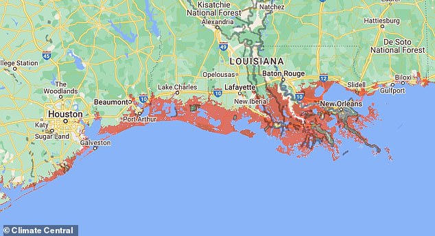
Over in the US, several towns and cities in the Southern states would likely be affected. This includes New Orleans in Louisiana, Galveston in Texas, and the Everglades in Florida
Further south, swathes of London would be affected.
Several areas on the River Thames gleam red on the map, including Bermondsey, Greenwich, Battersea, and Chelsea.
While the east coast of England would be most affected, several towns and cities on the west coast are also in the firing line, according to Climate Central.
Neighbourhoods on the outskirts of Weston-super-Mare, Newport and Cardiff would all be plunged underwater, alongside parts of Southport and Blackpool.
Residents in Northern Ireland and Scotland can mostly rest easy though, with few areas set to be affected.
Elsewhere in Europe, Climate Central predicts that the entire coast stretching from Calais to south Denmark would be underwater, along with Venice.
Over in the US, several towns and cities in the Southern states would likely be affected.
This includes New Orleans in Louisiana, Galveston in Texas, and the Everglades in Florida.

The researchers hope the findings will emphasise the urgent need to limit CO2 emissions. Pictured: artist’s impression of the Statue of Liberty underwater
The researchers hope the findings will emphasise the urgent need to limit CO2 emissions and curb global warming.
Professor Benjamin Horton, Director of the Earth Observatory of Singapore at NTU, said: ‘This NTU research represents a significant breakthrough in sea-level science.
‘By estimating the probability of the most extreme outcomes, it underscores the severe impacts of sea-level rise on coastal communities, infrastructure, and ecosystems, emphasising the urgent need to address the climate crisis.’


